
Who God's Eye View is for#
OSINT analysts tracking live global events
All thirteen data layers share a single coordinate system, so cross-referencing a vessel's position with satellite coverage, nearby seismic activity, and live camera feeds is a matter of toggling layers. The voice agent can answer analyst queries across live data ('which ships are headed to Oakland?') without leaving the globe.
Skip if:
Skip if your investigation requires classified feeds or premium-tier data not available through public APIs. God's Eye View works exclusively with publicly broadcast signals.
Security researchers monitoring air and maritime patterns
Live military flight tracking, AIS vessel monitoring, satellite orbital visualization, and mapped military installations from community OpenStreetMap data appear in one view. Cockpit mode lets you ride any tracked contact. Share links hand off a live target to colleagues as a URL rather than a static frame.
Skip if:
Skip if you need verified attribution or classified imagery. All data comes from open, publicly broadcast signals with no guaranteed accuracy for intelligence-grade or legal-grade use.
Journalists covering breaking geospatial stories
Active fires (NASA FIRMS), earthquakes (USGS), flight diversions, and vessel movements appear in real time on one globe. A URL with a tracked target hands off a live story to an editor or colleague as a link, letting them see what you are seeing rather than describing it.
Skip if:
Skip if publication requires proprietary or licensed geospatial imagery. God's Eye View displays public signal only and does not produce downloadable imagery cleared for commercial publication.
Developers building geospatial intelligence tools
The application is a JavaScript codebase with CesiumJS, WebGL GLSL shaders, and a modular layer system. All source is MIT-licensed and inspectable. The voice agent tool set is documented in the repo, so extending the 28-tool set or wiring in additional data layers follows established patterns in the codebase.
Skip if:
Skip if you need a production-ready geospatial data API with SLA guarantees. God's Eye View is a visualization client, not a hosted data service.
The problem it solves#
Open source intelligence is abundant but fragmented. Aviation transponders, ship AIS beacons, satellite orbital elements, seismographs, and city camera networks all broadcast continuously, but each feed lives in its own web service with no shared coordinate system, no way to track entities across layers, and no unified interface for real-time queries.
Analysts working across these feeds typically keep a dozen browser tabs open: one for flight tracking, one for maritime vessels, one for satellite positions, another for fire alerts. The cognitive cost of context-switching between disconnected interfaces is the real bottleneck. Commercial platforms that fuse these feeds into one interface charge hundreds to thousands of dollars per month, require vendor accounts, and keep the underlying data on their infrastructure rather than yours. Bilawal Sidhu built God's Eye View to pull those feeds into one globe, and his open-source announcement is explicit that the repo is a baseline for other people to bolt their own layers onto.
How it solves it#
Thirteen live data layers, eleven keyless
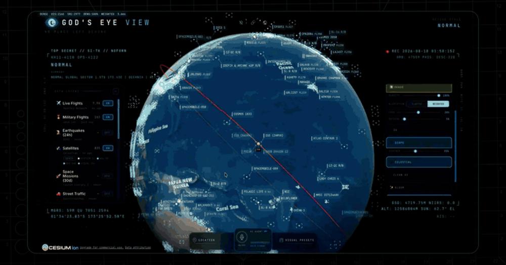
Covers live aircraft (11,000+ via OpenSky), military flights, maritime vessels, 838-satellite catalog, earthquakes (USGS 24h), active fires (NASA FIRMS), traffic, CCTV mesh (around 800 public cameras), geolocated radio (up to 750 stations), bikeshare, and space launches. Eleven layers require no API key or account to use.
Voice-controlled AI agent with 28 tools
An OpenAI-backed session agent pulls live scene context before answering, including coordinates, active layers, scale, and street names. Supports camera direction commands, voice annotation onto the globe with real boundary polygons, analyst queries across live layers ('how many flights are over Texas right now?'), and hands-free layer control. Requires an OpenAI API key.
Sensor style rendering through GLSL post-processing
Seven visual modes switch the entire live globe through GLSL shaders: normal satellite imagery, CRT, night-vision (NVG), FLIR thermal, Ironbow thermal, Noir, and Snow. Styles persist across cockpit mode and layer changes, letting you view live global traffic through any sensor perspective.
Cockpit view with live aircraft telemetry
Locks the camera onto any tracked aircraft and rides it with real terrain underneath. Nearby signals, regional headlines, and local weather appear in the cockpit briefing strip. A contact roster lists everything within 250 km so you can jump between tracked aircraft and fall straight into the next cockpit.
Shareable live target URLs
Camera angle, sensor style, active layers, and one tracked target all serialize into a URL. Sharing it sends the recipient to the same live view following the same moving target. A shared URL is a live handoff to a specific aircraft, vessel, or fire, not a static screenshot.
CCTV mesh projected into 3D space
Around 800 public cameras from Austin, California (Caltrans), and London (TfL) project their feeds into the 3D scene at real-world positions. Switching to viewshed mode draws each camera's estimated coverage volume. Poses are estimated priors you refine by dragging a gizmo directly on the camera object.
Strengths and trade-offs#
Strengths
- No account or signup required for core useEleven of thirteen live layers run keyless out of the box. The basemap falls back from Esri satellite imagery to OpenStreetMap automatically if Esri is unavailable. You can explore live aircraft, satellites, earthquakes, and radio stations from the first npm run dev without registering anywhere.
- MIT-licensed source code with no subscription costThe application code is MIT-licensed, so you can run it, modify it, and use it commercially with no licensing fee. Unlike commercial geospatial intelligence platforms that charge per seat or per API call, the only ongoing cost is the server you run it on, plus optional API keys for premium layers.
- 17,500+ GitHub stars with rapid, active developmentReached #1 on GitHub Trending and accumulated 17,519 stars since open-sourcing in June 2026. Last commit landed within 24 hours of the research date. 3,533 forks signal strong developer interest and an active downstream community.
- One-click install path via PinokioBeyond npm, Pinokio provides a no-terminal install that verifies the runtime, installs locked dependencies, finds a free local port, and opens the app automatically. API keys paste into a Provider Settings panel inside the app; the app restarts itself with the new capability active.
Trade-offs
- -Bundled datasets include CC BY-NC-SA restrictionsThe MIT license covers the application source code only. Bundled third-party datasets, including TeleGeography submarine cable data, carry CC BY-NC-SA 3.0 terms that restrict commercial redistribution. Self-hosters using the application commercially must review DATA_SOURCES.md and remove or separately license any datasets whose terms conflict with their use case.
- -Voice control and AI HUD require a paid OpenAI API keyThe voice agent and AI HUD summary both depend on an OpenAI API key. Without one, the mic button reports voice is unavailable and the AI HUD does not render. All thirteen live data layers, cockpit mode, sensor styles, and share links work without it, but the hands-free interface is unavailable.
- -Photorealistic 3D cities require an additional tokenThe keyless basemap provides Esri satellite imagery, not photorealistic 3D cities. Google Photorealistic 3D and world terrain require a free Cesium ion token (restricted to eligible personal, non-commercial use under current ion terms) or a billing-enabled Google Maps key. The keyless experience is functional but visually limited.
- -Requires Node.js 24.14.x or 26.xNode.js 25 is EOL and triggers a setup doctor warning rather than a hard block. Older Node versions are not supported. Teams running managed or shared Node environments may need to update their runtime version before the app runs.
God's Eye View vs alternatives#
God's Eye View vs Flightradar24 Business
Both tools display live aircraft on a map, but they serve different purposes. Flightradar24 Business is a managed subscription API with SLA-backed ADS-B data delivery; God's Eye View is a self-hosted application that fuses aircraft data alongside twelve other public signal types.
| Feature | God's Eye View | Flightradar24 Business |
|---|---|---|
| License | MIT (source code) | Proprietary |
| Self-hosting | Yes | No |
| Flight data source | OpenSky + adsb.lol (free tier) | Proprietary ADS-B network |
| Additional data layers | 12 more (vessels, satellites, fires, cameras, radio) | Flight-focused only |
| Voice control | Yes (OpenAI key required) | No |
| Cost | Free to self-host; optional keys for premium layers | $99+/month business plans |
God's Eye View is the better choice when you need flight data as one layer in a broader situational picture, cross-referenced with vessel positions, active fires, or satellite passes, with no subscription cost. Flightradar24 Business is the better choice when you need guaranteed ADS-B data quality, historical playback, or a stable API with SLA commitments that a production application can depend on.
God's Eye View vs ArcGIS Online
ArcGIS Online is the dominant commercial GIS platform for spatial analysis and enterprise mapping. God's Eye View is a live intelligence viewer optimized for real-time public signal; the comparison is relevant for teams choosing between a browser-based situational awareness tool and a full geospatial analytics subscription.
| Feature | God's Eye View | ArcGIS Online |
|---|---|---|
| License | MIT (source code) | Proprietary |
| Self-hosting | Yes | No (cloud-hosted) |
| Real-time live feeds | Yes (13 layers, 11 keyless) | Requires additional integration |
| Voice control | Yes (OpenAI key required) | No |
| Cost | Free to self-host | $100+/user/year |
| Learning curve | Low for live intelligence | High for spatial analysis workflows |
ArcGIS Online is the better choice for teams that need spatial analytics, organizational data editing, enterprise support, and compliance. God's Eye View is the better choice for analysts who need a live situational picture of public global signals without deploying GIS infrastructure or paying per-seat fees.
Quick start#
Deploy locally by running npm install from the cloned repo root, then start the dev server.

```bash
npm install
npm run dev
```What it's built on#
- Languages
- JavaScript
FAQ#
Is God's Eye View free to use?
The source code is MIT-licensed and free to run on your own machine. Eleven of thirteen live data layers need no API key or account. Optional upgrades, including Google Photorealistic 3D cities (via a free Cesium ion token for personal non-commercial use), live vessel tracking (via AISStream), and voice control (via OpenAI), each have their own free tiers. There is no subscription fee for the application itself.
What do I need to run God's Eye View locally?
Node.js 24.14.x or 26.x and npm. Clone the repo, run npm install, then npm run dev. The app opens at http://localhost:4173 with live aircraft, satellites, earthquakes, and radio stations already on the globe. No account or API key is required to start exploring.
Can I use God's Eye View commercially?
The application source code is MIT-licensed, so you can use and modify it commercially. However, some bundled third-party datasets, including TeleGeography submarine cable data under CC BY-NC-SA 3.0, restrict commercial redistribution of those specific datasets. Review DATA_SOURCES.md and remove or separately license any conflicting datasets before deploying in a commercial context.
Does voice control work without an OpenAI key?
No. The voice agent and AI HUD summary both require an OpenAI API key. Without one, the mic button reports voice is unavailable. All thirteen live data layers, cockpit mode, sensor styles, and shareable URLs work fully without any OpenAI key; only the voice interface is gated.
How does God's Eye View compare to Flightradar24 or ArcGIS?
Flightradar24 and ArcGIS Online are commercial platforms with subscription costs and managed infrastructure. God's Eye View runs on your own machine at no subscription cost and fuses more source types: aircraft, vessels, satellites, earthquakes, fires, cameras, and radio in one view. The tradeoff is that God's Eye View requires technical setup and carries no data accuracy guarantees or customer support commitments.
Similar open-source tools#

inspo
903 GitHub starsReal production sites as design reference for AI coding agents
Alternative to Refero

bg0
364 GitHub starsBackground removal that runs in your browser, never uploads
Alternative to remove.bg

hyperframes
65,842 GitHub starsTurn HTML and CSS into rendered MP4 videos, built for AI agents.
Alternative to Remotion
garden-skills
12,987 GitHub starsProduction-ready agent skills for Claude Code, Cursor, and Codex


Jasna
2,411 GitHub starsGPU-accelerated mosaic detection and restoration for video and images
Alternative to UniFab Video Enhancer